1835 Pike Road
La Porte, CA 95891
(916) 300-6681

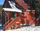
La Porte Cabin Rentals
Rustic Yet Refined
Things to Do
La Porte is surrounded by the Plumas National Forest. Its a great place to get away from modern life and enjoy the pleasures of hiking, fishing, nature walks, mountain biking, cross country skiing, snowmobiling or just relaxing on the porch.
In the Winter there's lots of snow for cross-country skiing and snowmobiling. You can start your cross country ski, snowshoe, or snowmobile trip right out the front door of your cabin.
In the Summer, Little Grass Valley Lake is just 4 miles up the road. There's lots of small streams and miles of trails Ito hike and fish or picnic by. The Pacific Crest Trail passes through this portion of the forest not far from La Porte.
There's many historic town sites and cemeteries in the area. Some within walking distance and others within a few hours drive.
Little Grass Valley Reservoir
Before the gold rush, Little Grass Valley was a mountain meadow thru which the South Fork of the Feather River meandered. During and after the rush, up until the early 1960’s the valley was used as a supply post, Boy Scout camp and grazing land. In the early 1960’s the river was dammed and Little Grass Valley Lake was formed. Today the lake is a true jewel in the Lost Sierra. Its 1600 acres provide camping, boating, diving, fishing, hiking, swimming and picnicking. Wildlife in the area includes deer, bear, beaver, marmot, bald eagle, osprey and geese. Fish include rainbow, brown and brook trout as well as kokanee salmon and even catfish.
Start of our trip is at the corner of Church street and China alley. Set or note your odometer reading. Turn right on to Main Street, traveling east through "downtown" La Porte.
.9 On the right note the Howland Flat Road. Save this trip for a more adventurous day.
1.7 On the right note the Quincy Road. This mountain pass route is completely paved but please put your vehicle in low gear when going down into the canyon to the Feather River. You will pass active gold dredgers and enjoy scenery seldom seen by the faint hearted. It is 33 miles to Quincy, our county seat.
2.7 LGV recreation area information area and turnout. Stop if you want. Continue straight.
3.3 Entrance to the Peninsula Campground, boat launching and Pancake Beach. Part of the year the Peninsula Campground is closed to provide a nesting area for the bald eagles that live at the lake.
4.1 Private land but a favorite shore fishing spot with the locals.
4.3 Public access trail as well as a fishing spot. Trail goes left and all the way around the lake. Road turns to gravel at 5.1 for a couple of miles. 5.2 fishing spot.
5.9 Stop here and see if you can spot the osprey nest at the top of the forked tree on the right.
7.0 South side of the dam, views of the South Fork. There is a nice hike down to the water jetting out of the dam base.
7.2 North side of the dam and spillway. Popular for fishing.
7.7 Black Rock campground, boat launch and picnic area.
7.8 "Y" in road. Road 57 continues around the lake. Road 94 turns left and eventually you wind up in Feather Falls. Take road 94 for a brief 1.2 mile side trip to frog pond and a spectacular lake overlook on the left. Back down the hill to the junction of 94 and 57 and continue around the lake.
9.6 To Black Rock Creek, Fowler Peak and Pacific Crest Trail access by road.
13.9 South Fork of the Feather River. A road just before the bridge winds back along the river. A nice spot to stop at .4 miles from the road.
14.1 Continue right at the "Y" around the lake on road 57.
14.9 Running Deer Campground
15.3 Red Feather Campground
15.7 Little Beaver Campground. Boat launching as well as swimming with changing pavilions.
16.1 Should find you back at the information sign and turnout. Continue back to La Porte to Reilly's Saloon and Cafe for libations and to celebrate completion of the trip.
Note: Little Grass Valley has a trail completely around the lake for hikers. It can be accessed from the campgrounds, the public access area and the South Fork bridge. The south side crosses some public land but the trail and the lake are public right of ways. The south side is for hikers only. The north side allows horses are well as mountain bikes. Please, when enjoying the Lost Sierra, respect the land and pack out all litter.
Road Trip, Hike: Gibsonville, Onion Valley and Pilot Peak
This trip can be accomplished with a 2 wheel drive on gravel and dirt roads. Side jaunts require vigorous hiking. Please be prepared to take responsibility for yourself and respect the forest. Please pack out all litter.
Start at the corner of China Alley and Church Street. Set or note your odometer reading. Turn right on to Main Street traveling east passing the famous Reilly’s Saloon and Cafe.
1.7 Turn right on the Quincy-La Porte road. It is 33 miles to Quincy, the county seat of Plumas County.
6.6 The intersection of the Quincy road and the Johnsville road, usually marked with signs to the Baptist Camp. Turn right and park. The second road to the right is the site of Gibsonville, once a thriving town with saloons, brewery, a newspaper and a downtown area. Explore it on foot. Wander down the site of the Masonic Temple and down to the diggin’s. Be vigilant to find ruins. Gibsonville was occupied until the 70’s. After exploration, return to the Quincy road and continue your journey.
10.9 "Y" in the road and a great overlook. Stop and view Mt. Lassen to the north. On a clear day you can see evidence of broken mountain peaks surrounding Lassen. Mt. Lassen is an active volcano, which last erupted in the early part of the 20th century. These mountain peaks as well as Lassen are remains of giant Mt. Tehama.
This is where the Pacific Crest Trail crosses the Quincy Road. Continue on the Quincy-La Porte road to the right.
12.1 Onion Valley. A beautiful alpine valley. Across the valley note the site of an old mine which is now called the rat’s hotel by the locals.
12.2 Trail on left to rat’s hotel.
12.3 Road to pilot peak. Turn right and proceed .5 miles to the top of the saddle. Check out the views. 3 options are available. Park and hike the road to the left uphill to the top of Buzzard’s Roost for more views or take the road to the right another .6 miles to another "Y". Park and hike to the right up to the top of Pilot Peak for spectacular views of Lassen, Shasta and even Nevada. Both these hikes are uphill and steep. Option 3 is to stay where you are and enjoy the view before proceeding on.
Return to the Quincy road and turn right .10 of a mile on the left is the road to Cleghorn Bar. The last 2 miles are for quality 4 wheel drives only. This leads to the Middle Fork of the Feather River, a wild and scenic river. If you have 2 wheel drive you can turn on the Cleghorn Bar road anyway for the first few miles. This road also offers spectacular views and sweeping meadows as well as lots of wildflowers in June and July. After exploration, return to the Quincy-La Porte road.
Turn right back toward La Porte. Reset odometer.
1.5 To "Y" and Lassen Peak overlook and the Pacific Crest Trail. The shortest way to La Porte is to the left, back the way you came. For an alternate way back to La Porte, turn right for a drive through the forest to Silvertip Springs near Little Grass Valley. Follow the signs to La Porte, turning left on to the Little Grass Valley road, finally ending up back in La Porte.
Return to La Porte and the Reilly's Saloon and Cafe for a well deserved meal after the arduous day of hiking.
Road trip, Hike: Slate Creek, Queen City, Port Wine and Howland Flat
This trip may be accomplished by 2 wheel drive on dirt and gravel roads. It covers a lot of territory as well as history. The entire trip can take 4 hours or longer depending on stops. As usual please respect property rights especially those of the pioneers in the cemeteries. When you take this trip or any other off road adventure please be prepared, take responsibility for yourself and pack out litter.
Set or note your odometer at the corner of China Alley and Church Street. Note the La Porte cemetery on your right as you leave town. This is well worth a visit when you return.
.2 On the left is the famous La Porte sanitary disposal area (dump). Around the dump and throughout the area, you will notice eroded hillsides and piles of rock and gravel. These are the remains of mining activity in the1800’s. The remains are called "spoils" and the sites themselves "diggin's". Much of the area was mined with huge amounts of water. This was called hydraulic mining and was outlawed in the late 1800’s. Gold was the number one reason for La Porte and the surrounding mining towns to exist. Water was the number one methodology used to get the gold.
.9 Road to Spanish diggings another larger example of hydraulic mining. Walk to the overlook or drive down.
1.9 The bridges of Slate Creek. A good place to stop at the wide spot right after the bridge and an excellent area for sunning and exploring. Slate creek was heavily mined and evidence can be seen all about. In fact, a channel was blown through the rocks under the first bridge to divert the water in order to make the channel more accessible. Rabbit Creek flows through La Porte and joins Slate Creek from up the hill near the bridge.
3 .7 On the left is the remains of the Sierra County maintenance building which was in use until the 1950’s. Stop and look over the bank to the right and see if you can identify the portal of an old mine. Remember this is private property so trespassing is forbidden.
3.9 "Y" in the road. This is more or less the site of Queen City, Sierra County, another booming gold town. For the next .5 mile evidence of activity are above and below you. Stop and look if you wish. There are old flumes, old house sites and mines. Then go right.
4.4 Stop and look up the hill to the left for the reputed remains of the Wells Fargo building. You are now in Port Wine.
4.5 "Y" in the road. Go straight or slightly right. Lot’s of diggin’s.
4.6 Port Wine cemetery. Stop if you wish and respectfully check out this historic site. Veterans of the Civil War are here.
Turn around and follow the road back to the first "Y" at Queen City. Odometer should read 5.4 and go straight.
6.2 Slight "Y" stay left. In many cases we do not discuss every possible turn off or "Y". Always stay on the main road.
6.6 Note old buildings on the right. They extend back up the hill.
6.7 Stop and look at the huge mine operation called Pioneer pit on the right. Dead center of the pit is the start of a drainage tunnel that extends 1500 feet and is directly under the road and where you are parked.
7.1 Stop at the wide spot and view recent mining activities on the left at Gardener’s Point. This is the Brush Creek mine.
8.5 Cross a single wooden bridge over Little Slate Creek this is Cedar Grove Ravine. To the right and up the creek are some very pretty, secluded pools for sunning and dipping.
* 8.8 The road to the left takes you back to La Porte. This is the route you will be taking upon your return. If you wish you may take it now and return to La Porte, resetting your odometer now and following the guide at the next asterisk for mileage.
To continue to Howland Flat, go straight or to the right also resetting your odometer.
.2 Stop and look to the woods on your left. A faint trail lead to the St. Louis cemetery. St. Louis was another booming mining town. This cemetery is little visited and worth a visit.
.5 The actual site of St. Louis.
.6 Overlook of the diggin’s at St. Louis.
3.4 To 3.6 area of past and current mining activity.
4.0 Past and current diggin’s.
4.4 Howland Flat. Stone building on the right. Howland Flat was a prosperous mining town settled in the early 1850’s. In 1861 the Union Tunnel company washed out 110 ounces of gold in 8 hours. Howland Flat continued its boom or bust cycle until the early part of the 20th century.
4.5 Miner’s home building on right.
4.8 Park and stroll through the cemeteries. The one on your right (uphill) is a catholic cemetery while the one to the left (downhill) is a Protestant one. Straight-ahead is the Winkeye Mine, which was in operation last in the 1980’s.
Straight-ahead past the Winkeye Mine is the road to Poker Flat which should not be attempted without a very sturdy 4 wheel drive vehicle or a mule.
After you have explored this historic area, retrace your route to the last major "Y" about 4.8 miles.
*Reset at "Y" to continue back to La Porte. Turn right if coming from Howland Flat, left if you are not continuing to Howland Flat and coming from Port Wine. Look to the left as you travel this road for great views.
.7 Old and new Slate Creek Bridge and miner’s tunnel. Stop and explore. To the right is a picnic area. Across the bridge next the old historic cement one, you can view a tunnel carved from one side of Slate Creek to the other. This was done as a diversion to allow easier mining of the bend in slate creek.
5.0 Overlook the town of La Porte on your left. Can you see your cabin on China Alley?
5.2 Pavement at last. Turn left and its .7 miles to La Porte where you can wrap up you adventure with a treat from Reilly's Saloon and Cafe.
WELCOME TO HISTORIC RABBIT CREEK
It maybe hard to believe but you are standing on a street which once was crowded with miners, mules, horses and fortune seekers from all over the world and had 3 hotels, dozens of mercantile stores, 14 saloons. a theater, newspaper office and a bank.
You are about to take a walk through time, into the historic town of Rabbit Creek. You'll have to use your imagination a bit but the FRANK C. REILLY CHAPTER of the E CLAMPUS VITUS has made your tour easier by erecting monuments along your route.
The tour starts on the porch of the historic "BUNKHOUSE " on the corner of Main Street and Pike Road. The Bunkhouse has a truly checkered past. During the daytime it was an ice cream and sasparilla parlor but was quickly converted to Miguel's Saloon for the evening hours. The lower rear room was dug deep into the hillside and filled with tons of ice insulated with sawdust. There used to be ten rooms for rent by the week, day or hour. (For more information about the "BUNKHOUSE " rooms and the cabins on CHINA ALLEY please call 530-675-0850 or the website is www.laportecabins.com). The BUNKHOUSE building's main floor is the former home of RABBIT CREEK ANTIQUES & GIFTS. The main office of LA PORTE CABIN RENTALS is located inside .
Fuller and Buell Monument
Between the La Porte General Store and the Frank C. Reilly Museum, Fuller and Buell built the "Alturas Block" (the first fireproof building in Sierra county). In one of La Porte's many devastating fires, the roof burned but the walls still stood.
The La Porte General Store burned in 1966 and was a great loss to the town and to its inhabitants. A new store was built on the site of the old one but it could never capture the feeling the "old store" gave you. The old La Porte Post Office was in the back of the store with its old fashioned iron bars and pigeon holes for the mail. The last postmaster of La Porte was Georgia Hillman O'Rourke. The store was owned by Truman and Helen Gould from 1949 to 1977. (See "La Porte Scrapbook" by Helen Weaver Gould for a wonderful introduction to La Porte. This book is available for sale in the Frank C. Reilly Museum) The Gould's motto was: "If Gould doesn't have it, you don't need it."
Frank C. Reilly, E CLAMPUS VITUS Musuem is your next stop.
The museum is open weekends from Memorial Day to Labor Day.
FRANK REILLY, his wife LUCILLE and her mother MARIE SANDBERG were La Porte to most people from the late 1930's to the middle 1960's. In the 30's they (along with Marie's first husband Lucien Amey) extended their warm hospitality to all comers, first at the La Porte Hotel and later at Reilly's Saloon and Cafe. Frank was born in Forbestown and before becoming an innkeeper was the foreman of the Feather Fork Mine. Frank, Lucille and "Mom" were always ready to welcome you with hot food and drinks and good companionship.
Rabbit Creek House
Built in 1852 by Eli Lester, the Rabbit Creek house was the first permanent structure built in the town. Eli Lester became the first postmaster and was credited with introducing hydraulic mining in the area. The post mark at that time was Rabbit Town which may have paved the way to the name change in 1857 when Rabbit Creek was renamed "La Porte" to "honor" the home town of Frank Everts who was from La Porte, Indiana. Everts and Company was the dominant express office of the time and being on the good side of Frank was probably a good idea.
The CAYOT HOTEL is right across the street from you. The present building was built in 1906 on the site of three others that burned in La Porte's many fires. Josephine Cayot, along with her family, emigrated from France and the hotel which had its birth as Kitt's Hotel remained in the family until the late 1960's when it was bought by Harold Thrash and reopened. After Francis Cayot passed away, The hotel was operated by the Amey/Reilly family until World War Two gas and rubber shortages forced its closure. In the early 70's it was remodeled and modernized by a couple from Miami. Today it is again open with rooms, dining and a bar for conventions only.
Retrace your steps down Main Street past the La Porte Sports Center and return to Pike Road. continue down Pike Road to China Alley to the next monument.
Chinese in La Porte
The Chinese came to Rabbit Creek to make their fortunes in the mines and along the creeks. By the 1870's there were over 250, mostly men, in La Porte. On this site there once stood a mercantile store, lodging houses, an opium den and a house of prostitution. To your left there was a Chinese hospital. The Chinese had their own cemetery but preferred to have their bones sent back to China whenever possible. "Bury MY Bones in America" by Lani Ah Tye Farkas is an excellent history of the her family in La Porte and is still in print.
Continue down China Alley . To your left are the 3 restored China Alley Cabins available for rental by LA PORTE CABINS (530-675-0850. The cabins were built in the early 1870's for miners and were completely remodeled a few years ago. Each cabin has a kitchen, bathroom, queen size bed and they are fully equipped. The cabins as well as the BUNKHOUSE Rooms are open all year.
Continue down China Alley and turn left. To your right are two houses. One is very old and the other is a reproduction of a 19th century dwelling. Can you tell which one is authentic?
It's the second house and it still belongs to the Kingdon Family who's ancestor Richard Kingdon was superintendent of the Bellevue Mine at the turn of the last century. The house dates from the middle of the 1800's and is still used by the family.
To the left there are two houses up on the hill that were build by a Mr. Williams in the 1870's.
Continue down Church Street and you will come to the LA PORTE CEMETERY.
B.W. Barnes Monument
B.W. Barnes was a prominent member of the early La Porte community and was instrumental in bringing water to the town from a spring situated on Bald Mountain. The system has been updated and the old wooden pipes replaced by modern plastic but the water still flows over the same route as it did in 1868. Mr. Barnes was buried in the cemetery after a Masonic Funeral attended by friends from towns near La Porte. It was April and it was necessary to dig through 6 feet of snow and then the traditional 6 feet of earth to bury him. His body was removed by his family in the 20's and taken to Oregon (or so the story is told). We're not sure why! But many, many of La Porte's pioneers are buried here. As you enter the cemetery you will see a large Bustillous plot. The Bustillous family were teamsters in La Porte and both Mike and Joe were champion snowshoe racers. Maria Bustillous carried the mail on snowshoes to Strawberry Valley. Wander through the cemetery and you'll see many small unmarked graves of La Porte's children who died of the various epidemics that were so common in the 19th century. Some of the women died in childbirth or soon after. We have all tried to guess the identify of "OUR LITTLE WILLIE" but his name remains a mystery.
The famous snowshoe racer Frank Steward is buried here as well as Charles Hendel the well known surveyor and "dope maker" and womanizer. (Dope was what the miners called the racing wax that they put on the snowshoes (skis) and the dopemaker not the skier won the purse at the frequent races on Lexington Hill. See "LOST SIERRA- GOLD GHOST AND SKIS" by Bill Berry . There is a monument dedicated to the snowshoe racers of La Porte just off the road at the top of Lexington Hill.
You can continue your walk through the cemetery and out on to School Street. The little red schoolhouse was in use until the end of the 1940's and was opened again in the 1980's only to be replaced by a more modern building erected by the Plumas Unified School District. The original La Porte School was in the church building that stood at the entrance of the cemetery.
Continue down School Street to the Corner of School and Main.
The Catholic Church was on your right below the present hotel building.
La Porte Monument:
Millions of dollars of gold was extracted from the area and there is thought to millions more buried just below the surface. The site of the Masonic Hall where Jefferson lodge #97 F&AM had its meetings. Just to the right of the monument on Rabbit Creek where today a private residence stands today (See the display in the Frank C. Reilly Museum)
The "Fill"
This is the site of the Rabbit Creek Bridge which was replaced in the early 50's by a culvert and "fill". There are some wonderful old pictures of the old metal bridge and other subjects in the museum.
Continue over Rabbit Creek to Circle Drive where you can walk along Rabbit Creek and around to the Firehouse and up Main Street to the parking lot of Gold Country-Post Office.
Lotta Crabtree Monument
Lotta Crabtree was a very young girl when she came to Rabbit Creek with her mother. John Crabtree had come to California seeking gold and his family came by ship to join him from New York. He must have been bitten by the gold fever bug because he frequently disappeared and Mary Crabtree was left to manage by taking in boarders. Little Lotta learned to dance in Mart Taylor's Hall and the miners who were starved for anything that reminded them of their former life back home, showered her with gold. She and her mother left Rabbit Creek and toured the mining camps where Lotta became a sensation. She became the toast of San Francisco and New York. She and her mother returned in later years to Rabbit Creek for a short visit. Lotta's Fountain still stands in San Francisco reminding us of her fame. Lotta never married and left her considerable fortune to homeless animals. Her Mother's boarding house probably stood on the banks of Rabbit Creek down Bustillous Road.
The Bustillous Family's corrals and houses stood where the present day Gold Country building stands. The corrals were across the road and barns and out buildings on the corner opposite. The Bustillous teams of mules and horses were famous throughout the area.
Upper Dutch Diggin's
Now walk to the corner of Bustillous Road and Mooreville Road and continue down Bustillous Road. Off to the left before you get to Rabbit Creek was the La Porte Chinese Cemetery. According to Chinese custom their bones were sent back to China for burial so there are only a few actual graves there. The access to the cemetery is over private property today so it is not for public view.
Cross Rabbit Creek and you can follow the Snowmobile Trail over to Gold Street.
For the more adventurous turn left off the Snowmobile Trail just after you cross Rabbit Creek and continue to the waterfall at the end of the trail. You're walking through a whole area which was "hydrauliced : before the Anti-Debris Act of 1883 and this practice was halted. Irate farmers from the Sacramento Valley threatened to march on the miners (and did) and this destructive practice was halted. It's only in recent years that willows and alders as well as pines and firs have started to grow again since most of the topsoil was removed by the giant monitors which washed away tons of soil in the frantic hunt for riches.
Retrace your steps back to the Snowmobile Trail and you are in the area of "Dublin" where many of La Porte's Irish emigrants lived.
Straight ahead down the Snowmobile Trail will take you to the Quincy-La Porte Road and the La Porte Diggin's. Can you imagine what it must have looked before the hydraulic mining too its toll?
Turn right onto Gold Street and around to Aristocracy Drive where many houses of prominent residents once stood. Not many are left but one of the oldest houses sits way up on a hill on the sharp corner as you are headed back to Main Street. It was originally the home and office of Dr. Mussey. Dr. Mussey delivered many of La Porte's babies was well loved by all.
Main Street
Here you are back at the Bunkhouse and Reilly's Saloon. We hope you enjoyed your little walk through history and your stay with us at La Porte Cabin Rentals.

1835 Pike Road
La Porte, CA 95891
(916) 300-6681
©2017 La Porte Cabins, All Right Reserved